Cerys Line
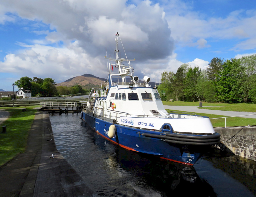
The Cerys Line is a 27m survey vessel perfectly suited for 24-hr operations and has an extensive track record in providing survey services since 2009.
The Cerys Line is a 27.5m LOA, 2.1m draft survey vessel with 24-hr operational capability and an endurance of up to 8 days. UK-registered, the survey vessel operates under the MCA workboat code Category 2 and can accommodate up to 4 marine crew and 4 survey crew members for 24-hr operations, with capacity available for a client representative.
Two diesel engines and two water jet engines allow for varying speeds of up to 12 knots, with survey speed of between 4-8 knots depending on water depths.
Permanently mobilised with a suite of advanced survey equipment
The Cerys Line is permanently mobilised with the latest generation survey equipment, including a Kongsberg EM2040 Compact (dual-head configuration; hull-mounted) multibeam echosounder (MBES) integrated with an Applanix POSMV OceanMaster GNSS-aided inertial navigation system.
QPS QINSy is utilised as the hydrographic survey management system which integrates the GNSS navigation solution and geophysical survey equipment to geo-reference the survey data.
A comprehensive suite of navigation equipment is equipped, including a Furuno FA150 AIS, Bridge Master E TRANSAS NaviRadar and Furuno Navnet VX2 radars interfaced with a TRANSAS NaviSailor ECDIS system, meeting IMO and SOLAS regulations.
Providing comfortable 24hr accommodation, the Cerys Line is equipped to accommodate four persons, with a galley, a TV lounge area and internet in all areas create a pleasant working environment.
Vessel Specifications
Flag: UK
SCV Work Boat Code: Category 2 (60 miles from safe haven)
Length overall: 27.5m
Beam: 5.82m
Draft: 2.1m
Gross Registered Tonnage: 75
Total of 8 berths for 24hr Operations: 2 x Single berth and 3 x twin berth cabins. Dedicated survey acquisition, separate gallery and mess areas
Service speed: 12 knots max – 10 knots cruising
Multibeam Echosounder: Kongsberg EM2040C (200-400KHz), Dual-Head, Dual-Swath, Hull Mounted
Side Scan Sonar*: EdgeTech 4200 Multi-Pulse (300-900KkHz)
Magnetometry*: Geometrics G882 Marine Magnetometer
Positioning System: Applanix POS MV OceanMaster
Motion Sensor: Applanix POSMV (Integrated) IMU
Sound Velocity: Valeport MiniSVS and Swift SVPs
Underwater Positioning*: Sonardyne Mini Ranger 2 USBL (side mounted pole)
Side-Mounted Pole: Purpose built side mounted pole and plates (port and starboard) for additional survey equipment as required
Navigation Software: QPS QINSy Integrated Navigation Solution
Processing Software: CARIS HIPS and SIPS, Chesapeake SonarWiz
* Equipment is optional and can mobilised and de-mobilised as required, along with additional equipment upon request.
Main Engines: 2 x Deutz Diesel SBA 16 M 816 – 1500HP each
Water Jet System: 2 x Volvo D6 – 330HP/Ultrajet 1-5 knots
Generators: 2 x John Deere 4045TFM50 57kW each
Bow Thruster:1 x Volvo D7 HPU – 50HP Thruster
Fuel capacity: 9,500 litres
Fresh Water: 2,400 litres
Black Water: 1,000 litres
Charting System: TRANSAS NaviSailor
Radar 1: Bridge Master E – TRANSAS NaviRadar
Radar 2: Furuno Navnet VX2
DGPS1 /SAT Compass: Furuno SC50
DGPS2: Litton LMX 406
UAIS: Furuno FA150
Auto Direction Finder: Simrad TAIYO
Echo Sounder 1: Furuno FCV620
Auto Pilot: Simrad AP50
Navtex: McMurdo NAV7
MF/HF SSB GMDSS DSC: Furuno FS-2571C
VHF 1 GMDSS DSC: Sailor 6222
VHF 2: Furuno FM8800
Handheld: 2 x Handheld GMDSS SOLAS VHF, 3 x UHF ICOM IC-F61V
Network: 1GB Ethernet network system, WLAN/Printer, 4G Internet connection
Phone: GSM Phone, IRIDIUM Sat Phone
Standard:
2 x 8-man Life Rafts, 8 x Immersion Suits, Fixed Buoyancy Lifejackets for 14 persons, 1 x SART, 2 x EPIRB
Cameras: Deck x 3, Engine Room x 4
Downloads
Cerys Line Vessel SpecificationInterested in a Career in Hydrographic or Geophysical Surveying?
If you enjoy working in the marine environment and using technology to explore and map the seafloor, then a career in hydrographic or geophysical surveying may be the ideal path for you.
At A-2-Sea Solutions, we specialise in providing high-quality hydrographic and geophysical surveys for many industries, including wind farm developments, cable installations, and the oil and gas sector.
Hydrographic surveying involves utilising advanced sonar technology, positioning systems, and software to collect and analyse data to produce nautical charts, which are essential for the safe and efficient navigation of vessels. On the other hand, geophysical surveying utilises various methods to investigate the geology of and beneath the seafloor.
At A-2-Sea Solutions, we value our surveying team's expertise, who have an unwavering commitment to quality, safety and take pride in delivering exceptional results to our clients. If you're keen on pursuing a career in hydrographic or geophysical surveying, we encourage you to check out our careers page for more information and contact us to find out how you can join our team.







© A-2-Sea Solutions Limited · Website by Nifty Solutions · Registered No. 03223673
